Tawa Fixed Route: Route 59
Introduction
Metlink is introducing a new ‘hail and ride’ bus service to Tawa, which will replace the previous On-Demand service. This is an interim measure as we transition from the previous operating model to a more standard fixed bus route. This will enable us to replace the service promptly.
Route 59 will begin on Monday 24 February. The new service will run Monday to Friday and start at 7.15am with a bus running hourly from each end of the route, Greenacres and Grenada North. Buses in each direction will travel via Tawa shops, Takapu Road Station and Linden Station.
The new route runs through parts of Tawa where there are no existing bus stops. To get this service up and running quickly, Metlink will use ‘stopping areas’ where bus stops do not currently exist.
These stopping areas are placed at safe locations along the route. They will not have physical signs or typical road markings on the street, but passengers can find stopping area locations on our journey planner website and timetables or see written descriptions of the stopping areas below.
As we review the service, we will also look to install more permanent stops where appropriate.
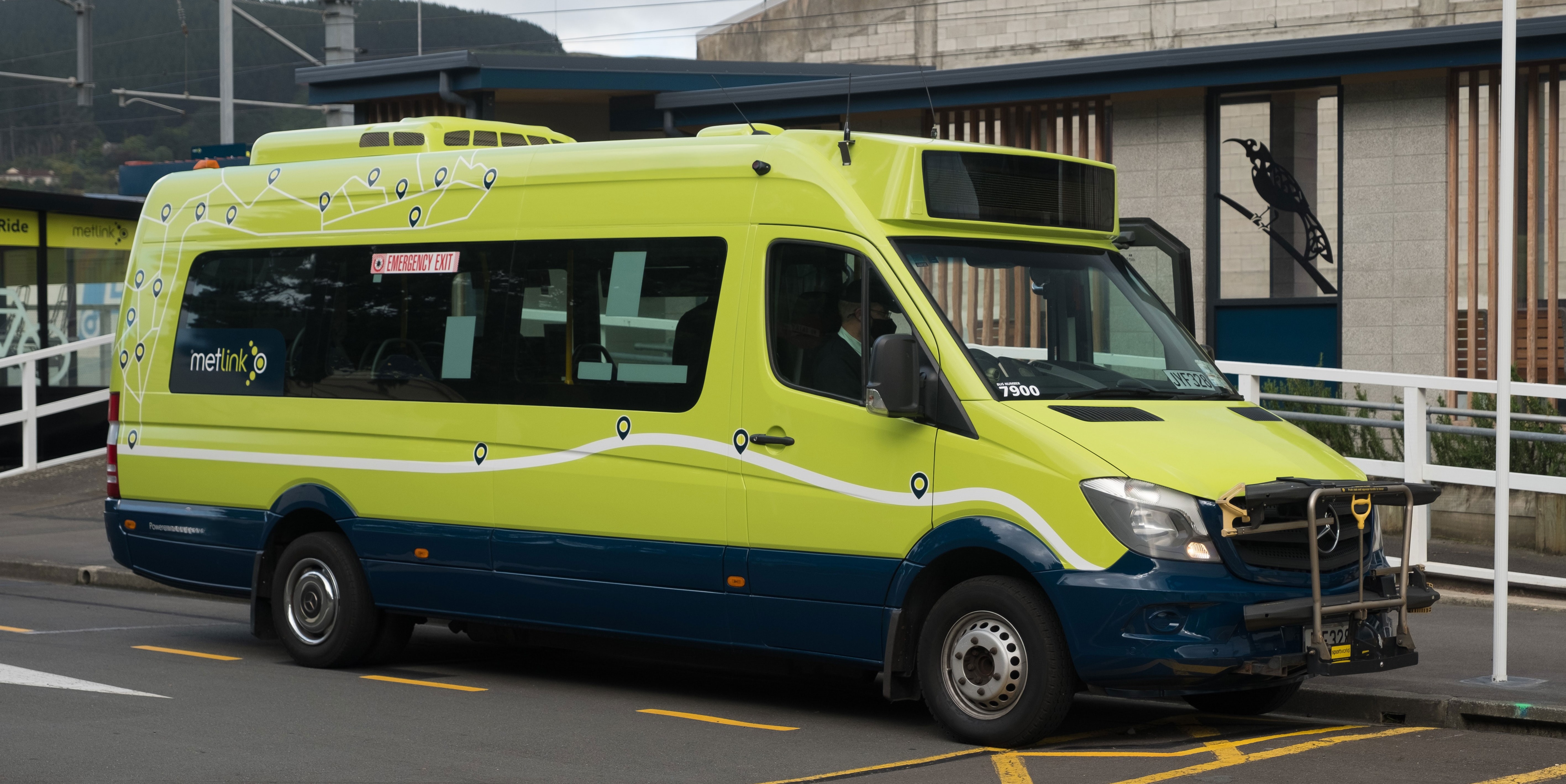
We will be using the same 20 person Sprinter buses as the previous service and will now have tag on/tag off Snapper facilities and new buzzers installed. Cash, and the SuperGold card are accepted as well.
Drop in sessions
Metlink invites you to learn about the new bus service, how it will operate, ask questions let them know what you think at one of the following drop-in sessions:
Tawa Community Centre - 5 Cambridge Street, Tawa
Thursday 13 February: 10am - 11am
Wednesday 19 February: 5pm - 6:30pm
Thursday 20 February: 10am - 11am
Kapi-Mana Bridge Club - 8 Linden Avenue, Linden
Friday 21 February: 12pm - 1pm
The Route
Route 59 will operate in two directions: Inbound (Greenacres – Tawa Shops – Grenada North) and Outbound (Grenada North – Tawa Shops – Greenacres).
The route includes a combination of existing bus stops and designated stopping areas. Each bus stop and stopping area has a unique stop number, which can be used with our Journey Planner, real-time information, or timetables.
Journey Planner(external link)
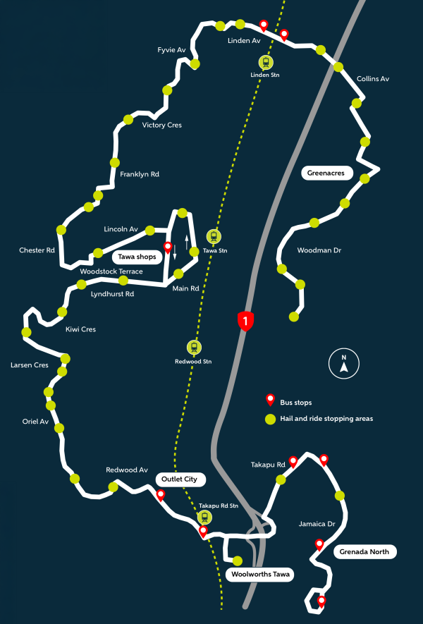
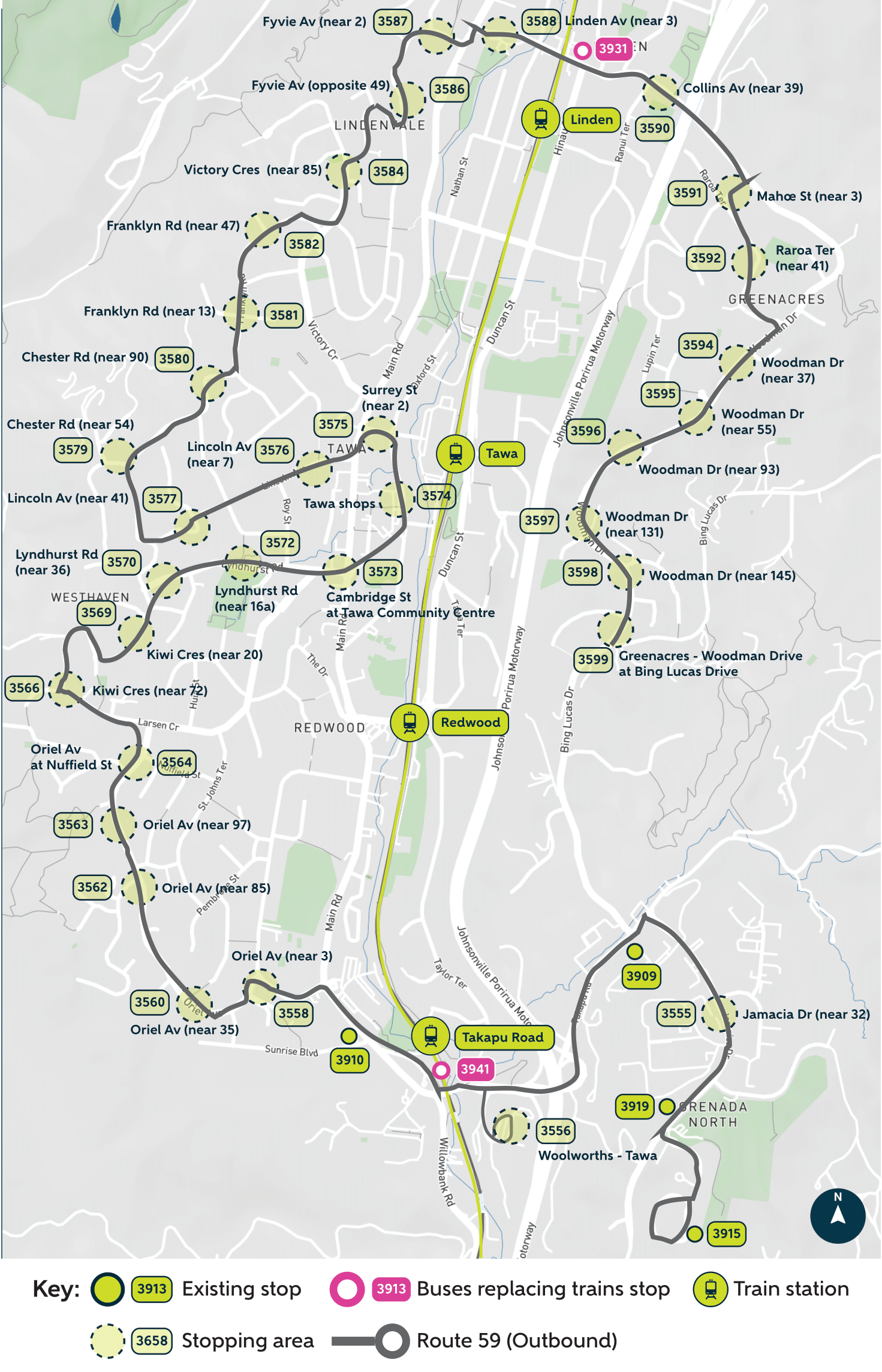
Map and overview of the full route and stopping areas
The stopping areas and stops differ for the Inbound and Outbound routes. Below is a map showing an overview of the route. For more specific information, please refer to the detailed maps for each direction to see the exact stopping areas, stops, stop numbers and descriptions.
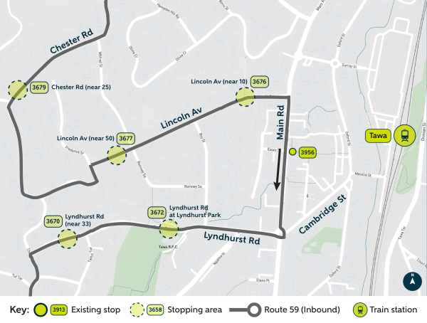
Route 59: Greenacres – Tawa Shops – Grenada North heads inbound/south towards Grenada North and Tawa Shops. The bus travels down Lincoln Avenue, turns right onto Main Road, then turns right again onto Lyndhurst Road, stopping at the existing stop 3956(external link) on Main Road.
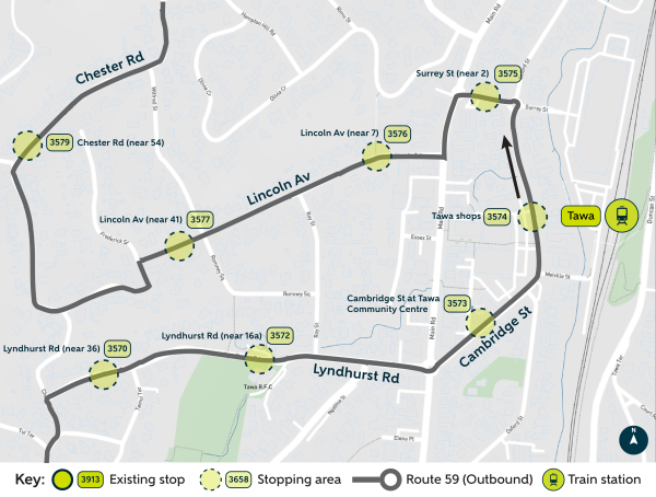
Route 59: Grenada North – Tawa Shops – Greenacres travels outbound/north towards Greenacres, passing around Tawa Shops. The bus goes down Lyndhurst Road, through the roundabout onto Cambridge Street, then continues to Oxford Street to stop at the New World. Afterward, it turns left off Surrey Street, then takes another left back onto Main Road, and finally turns right onto Lincoln Avenue.
Inbound route: Greenacres – Tawa Shops – Grenada North

| Type | Location Description | Stop Number |
|---|---|---|
| Stopping Area | Greenacres - Woodman Drive at Bing Lucas Drive | 3699(external link) |
| Stopping Area | Woodman Drive (near 142) | 3698(external link) |
| Stopping Area | Woodman Drive (opposite 121) | 3697(external link) |
| Stopping Area | Woodman Drive (near 72) | 3696(external link) |
| Stopping Area | Woodman Drive (near 46) | 3695(external link) |
| Stopping Area | Woodman Drive (near 24) | 3694(external link) |
| Stopping Area | Raroa Terrace (near 46a) | 3692(external link) |
| Stopping Area | Mahoe Street (near 6) | 3691(external link) |
| Stopping Area | Collins Avenue (near 36) | 3690(external link) |
| Existing Stop | Linden Station - Collins Avenue at Beauchamp Street | 3935(external link) |
| Stopping Area | Linden Avenue (opposite 3) | 3688(external link) |
| Stopping Area | Fyvie Avenue (opposite 2) | 3687(external link) |
| Stopping Area | Fyvie Avenue (near 47) | 3686(external link) |
| Stopping Area | Victory Crescent (opposite 85) | 3684(external link) |
| Stopping Area | Franklyn Road (near 48) | 3682(external link) |
| Stopping Area | Franklyn Road (near 18) | 3681(external link) |
| Stopping Area | Chester Road (near 49) | 3680(external link) |
| Stopping Area | Chester Road (near 25) | 3679(external link) |
| Stopping Area | Lincoln Avenue (near 50) | 3677(external link) |
| Stopping Area | Lincoln Avenue (near 10) | 3676(external link) |
| Existing Stop | Tawa Mall - Main Road (near 206) | 3956(external link) |
| Stopping Area | Lyndhurst Road at Lyndhurst Park | 3672(external link) |
| Stopping Area | Lyndhurst Road (near 33) | 3670(external link) |
| Stopping Area | Kiwi Crescent (near 17) | 3669(external link) |
| Stopping Area | Kiwi Crescent (near 69) | 3666(external link) |
| Stopping Area | Oriel Avenue (near 112) | 3664(external link) |
| Stopping Area | Oriel Avenue (near 88) | 3663(external link) |
| Stopping Area | Oriel Avenue (near 68) | 3662(external link) |
| Stopping Area | Oriel Avenue (near 28) | 3660(external link) |
| Stopping Area | Oriel Avenue (near 8) | 3658(external link) |
| Existing Stop | Main Road Tawa opposite Sunrise Boulevard | 3962(external link) |
| Existing Stop | Takapu Road Station - Boscobel Lane at Station | 3951(external link) |
| Stopping Area | Woolworths Tawa | 3556(external link) |
| Stopping Area | Takapu Road (near 21) | 3656(external link) |
| Existing Stop | Jamaica Drive (near 17) | 3913(external link) |
| Stopping Area | Jamaica Drive (opposite 32) | 3655(external link) |
| Existing Stop | Jamaica Drive at Grenada North Park | 3917(external link) |
| Existing Stop | Grenada North - Nassau Avenue (near 49) | 3915(external link) |
Outbound route: Grenada North – Tawa Shops – Greenacres
| Type | Location Description | Stop Number |
|---|---|---|
| Existing Stop | Grenada North - Nassau Avenue (near 49) | 3915(external link) |
| Existing Stop | Jamaica Drive opposite Grenada North Park | 3919(external link) |
| Stopping Area | Jamaica Drive (near 32) | 3555(external link) |
| Existing Stop | Takapu Road opposite Bing Lucas Drive | 3909(external link) |
| Stopping Area | Woolworths Tawa | 3556(external link) |
| Existing Stop | Takapu Road Station - Boscobel Lane opposite Station | 3941(external link) |
| Existing Stop | Main Road Tawa at Sunrise Boulevard | 3910(external link) |
| Stopping Area | Oriel Avenue (near 3) | 3558(external link) |
| Stopping Area | Oriel Avenue (near 35) | 3560(external link) |
| Stopping Area | Oriel Avenue (near 85) | 3562(external link) |
| Stopping Area | Oriel Avenue (near 97) | 3563(external link) |
| Stopping Area | Oriel Avenue at Nuffield Street | 3564(external link) |
| Stopping Area | Kiwi Crescent (near 72) | 3566(external link) |
| Stopping Area | Kiwi Crescent (near 20) | 3569(external link) |
| Stopping Area | Lyndhurst Road (near 36) | 3570(external link) |
| Stopping Area | Lyndhurst Road (near 16a) | 3572(external link) |
| Stopping Area | Cambridge Street at Tawa Community Centre | 3573(external link) |
| Stopping Area | Tawa Shops - Oxford Street at New World | 3574(external link) |
| Stopping Area | Surrey Street (near 2) | 3575(external link) |
| Stopping Area | Lincoln Avenue (near 7) | 3576(external link) |
| Stopping Area | Lincoln Avenue (near 41) | 3577(external link) |
| Stopping Area | Chester Road (near 54) | 3579(external link) |
| Stopping Area | Chester Road (near 90) | 3580(external link) |
| Stopping Area | Franklyn Road (near 13) | 3581(external link) |
| Stopping Area | Franklyn Road (near 47) | 3582(external link) |
| Stopping Area | Victory Crescent (near 85) | 3584(external link) |
| Stopping Area | Fyvie Avenue (opposite 49) | 3586(external link) |
| Stopping Area | Fyvie Avenue (near 2) | 3587(external link) |
| Stopping Area | Linden Avenue (near 3) | 3588(external link) |
| Existing Stop | Linden Station - Collins Avenue opposite Hinau Street | 3931(external link) |
| Stopping Area | Collins Avenue (near 39) | 3590(external link) |
| Stopping Area | Mahoe Street (near 3) | 3591(external link) |
| Stopping Area | Raroa Terrace (near 41) | 3592(external link) |
| Stopping Area | Woodman Drive (near 37) | 3594(external link) |
| Stopping Area | Woodman Drive (near 55) | 3595(external link) |
| Stopping Area | Woodman Drive (near 93) | 3596(external link) |
| Stopping Area | Woodman Drive (near 131) | 3597(external link) |
| Stopping Area | Woodman Drive (near 145) | 3598(external link) |
| Stopping Area | Greenacres - Woodman Drive at Bing Lucas Drive | 3599(external link) |
Hail and Ride
Stopping Areas vs Bus Stops
Similar to the On Demand service, some areas along the route will be designated as stopping areas where the bus can pick up and drop off passengers. These stopping areas will generally not have signage and are simply safe spots on roads along the route. Existing bus stops will also be used where available.
Stopping areas will have a stop number allocated to them so you can check the timetable and real-time information.
All stopping areas will be placed in safe locations where passengers can wait and board the bus, ensuring good visibility for drivers.
Getting On and Off the Bus
Passengers can hail the bus at existing bus stops on the route, or within the stopping areas.
Once onboard the bus, passengers can push the buzzer or inform the driver that they want to get off. The driver will then stop at the next bus stop or stopping area.
Hours & Fare Information
Monday to Friday
- First Service: 7:15 AM
- Last Service: Just after 6:00 PM
- Runs hourly from each end
- No weekend service
On-peak (7 AM - 9 AM and 3 PM - 6:30 PM)
| Type | Cash | Snapper |
|---|---|---|
| Child | $1.50 | $1.01 |
| Adult | $3.00 | $2.02 |
| Tertiary Snapper | - | $1.52 |
| Accessible Snapper | - | $1.01 |
| Community Connect Snapper | - | $1.01 |
| SuperGold Card | $3.00 | $2.02 |
Off-peak (6:30 AM - 7 AM and 9 AM - 3 PM)
| Type | Cash | Snapper |
|---|---|---|
| Child | $1.50 | $0.51 |
| Adult | $3.00 | $1.01 |
| Tertiary Snapper | - | $0.76 |
| Accessible Snapper | - | $0.51 |
| Community Connect Snapper | - | $0.51 |
| SuperGold Card | Free | Free |
Payment Options:
- Snapper card or cash.
- SuperGold card is accepted during off-peak hours for free travel.
Accessibility
Accessibility
At this early stage of introduction, Route 59 is not a fully accessible bus service. This is because we had to introduce the service quickly to give the Tawa community access to public transport after Metlink On Demand ended in December. Metlink is committed to improving the accessibility of this service overtime in collaboration with disabled people.
Accessibility of Stopping Areas
While there are some accessible bus stops on the route, most of the route 59 has hail and ride stopping areas.
When waiting at stopping areas, position yourself in a safe place on a foot path where you can be seen by the driver. It’s helpful to signal to the driver that you’re waiting to catch the bus by facing the direction the bus is coming from and waving out.
Some stopping areas are on steep hills, grass berms and may not have a footpath or kerb to allow the driver to safely put down the ramp. This means that some stops are unsafe and inaccessible for those who use mobility aids like wheelchairs and walkers.
Metlink is evaluating the safety of each stopping area for our customers who use mobility aids. Once this audit is complete, we will publish information identifying which of the stopping areas are accessible.
Accessibility of Buses
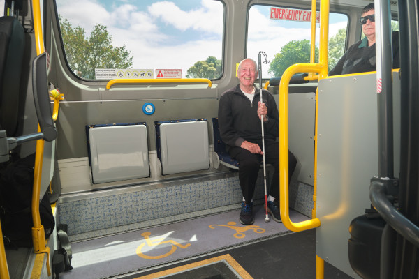
Smaller Sprinter buses that can take up to 20 people are used on the route 59. These buses have a ramp and low floor entry. There is a priority seating area at the front of the bus with fold down seats and space for one wheelchair or pram.
Frequently asked questions
How did you design the route?
The basis for this route has been taken from public submissions, On Demand service route data and public engagement.
Why do you have ‘stopping areas’?
Stopping areas are an interim measure we have put in place so can we quickly replace the on-demand service. Bus stops will be added to the route over a period of years, in consultation with residents.
Will I still be picked up if I am not within a ‘stopping area’?
To ensure road safety we cannot pick up passengers outside the stopping areas of the regular stops.
What about the residents of Kenepuru and Summerset?
Metlink is working on adjusting routes 60 and 60e in the area to accommodate these passengers. This will be later in the year. More details to come
Last published: Monday, 10 February 2025 at 1:13 am