Golden Mile and Harbour Quays Second Spine
Decisions on vital bus priority work on the Golden Mile and the development of a second public transport corridor along the harbour quays are indicative only and reliant on key decisions and processes from both councils.

Greater Wellington (GW) and Wellington City Council (WCC) are forming a partnership to design and implement a range of integrated public transport solutions across the city including bus priority, capacity and infrastructure improvements on the golden mile and planning on a second spine along the harbour quays.
Planning for an improved Golden Mile working in tandem with a new bus route through the city has been underway since 2018, and when complete, will improve speed, reliability and efficiency of public transport as well as deliver a variety of associated benefits to people walking, biking and driving along these corridors, including reducing congestion. Around 90% of Wellington city bus trips use the Golden Mile and 70% of bus trips across the region, so this integrated package of improvements is the single most important lever we can pull to get more buses through the city and improve Wellington public transport for everyone.
The current proposed design of the Golden Mile factors in the proposed additional public transport spine and work is already well advanced with a new road layout and bus stops designed for Courtenay Place with the new Harbour Quays bus route in mind. It's important to note that the current proposed plan for the golden mile will improve bus flow and bus capacity, but, given the narrow sections on Willis Street and the southern end of Lambton Quay, there is no way to increase capacity sufficiently without an additional parallel bus route through the central city.
Figures for these projects are indicative at this stage and reliant on the outcomes of a number of key decisions and processes, including the long-term plans of both councils and decisions from central government on major transport questions including congestion or time of use pricing for roads and investments in the State Highway around the Basin Reserve and Mt Victoria or, as recently suggested, a mega road tunnel linking the Beehive to the airport.
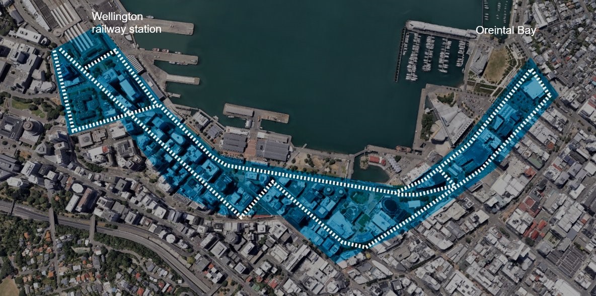
With maximum capacity for bus operations on the Golden Mile imminent in 2025, the $57m indicative budget for the second spine provides an alternative route in and out of the city making use of the extensive road space on and closer to the Harbour Quays. While locations are not yet decided, this would ideally add bus stops serving the waterfront, Te Ngākau Civic Square, Tākina Convention Centre and Te Papa and ease bottlenecks and capacity constraints as more and more people use public transport. Bus lanes seem simple but there's a lot of work to sort out the road space, traffic lights, crossings and other public amenities. So there will be significant civil works focused on rapid improvements to traffic flows and congestion so that people can get across the city faster to key regional destinations like the hospital and airport.
The second stage business case is part of the standard procedure that councils use. This investment fits with the Government's draft transport policy statement and we very much hope it will be supported by the NZ Transport Agency Waka Kotahi. It’s imperative that any major transport, housing and urban development decisions are integrated in the planning beyond this investment and it’s envisaged this work would be integrated with any future plans for the State Highway around the Basin and Mt Victoria tunnel.
The $12m indicated for shelters and signs is shorthand for the complete range of bus stop infrastructure upgrades along the length of the Golden Mile. These are complex builds that have to consider wind and earthquake resilience among other technical aspects. The indicative budget includes the necessary foundation works, shelter fixtures, and the service and technological components needed for improved real time information, in stop displays and improved security features. Similar major bus hubs elsewhere in Wellington are in the same ballpark for costs, like the hospital and Kilbirnie hubs for example. Building high quality engineered public structures with chunky foundations on Wellington road space doesn’t come cheap.
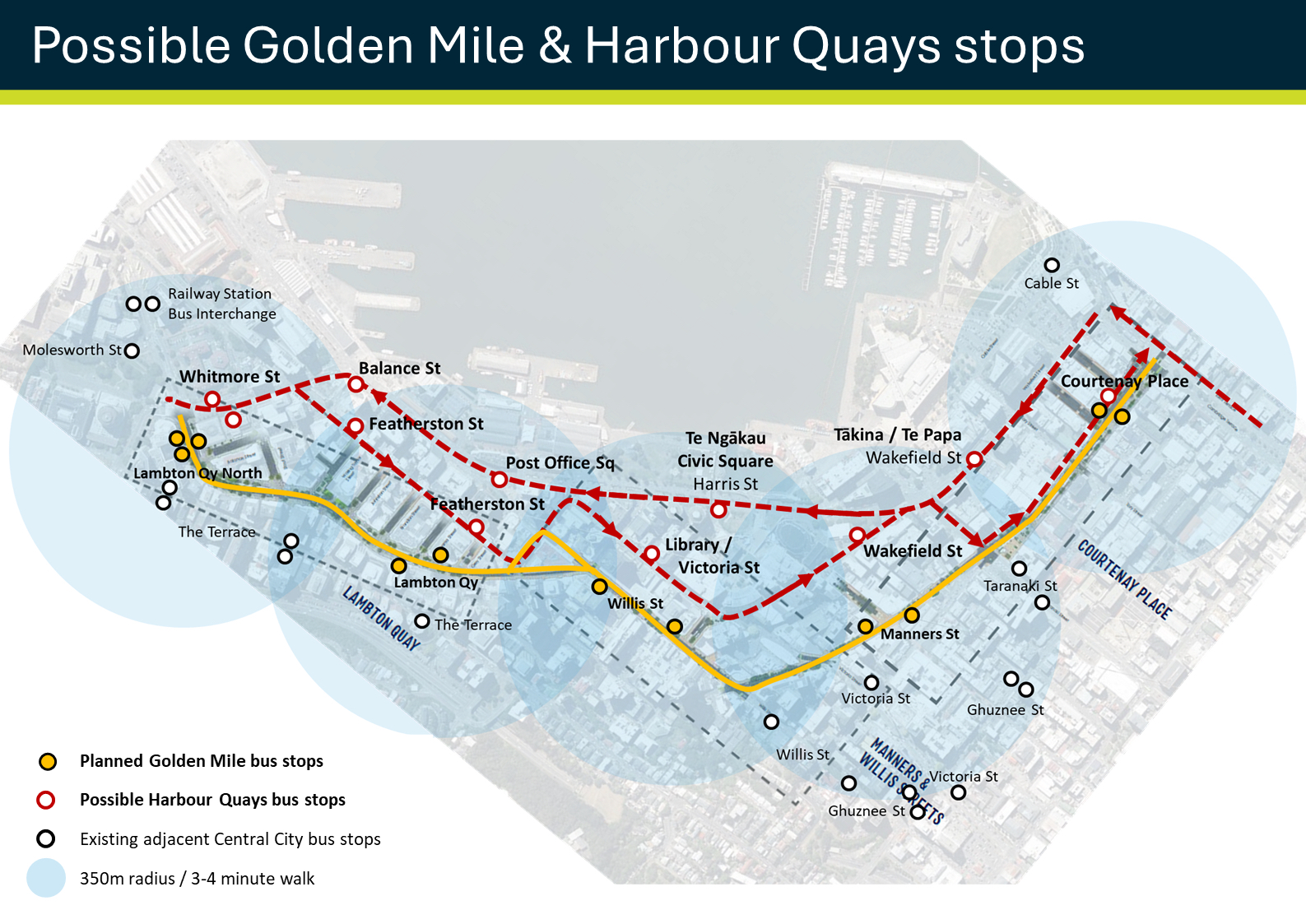
There are currently 15 bus stops along the Golden Mile and the plan is to increase shelter space in the central city with 10 much higher capacity bus stops on the Golden Mile, plus additional six bus stops to be added along the proposed new bus route parallel to the Golden Mile. All of this will be done based on community feedback, GIS modelling and pedestrian access information to better place where stops need to be, so people have access to shelters in the right places and bus journeys flow smoothly. We need a good balance between the number of bus stops and the length of journey times and we haven’t got it right now on the Golden Mile. These changes would result in no change in the number of inline bus stops.
As with all public transport projects, Greater Wellington will work with the NZ Transport Agency Waka Kotahi on the standard funding assistance rate, which is typically 51% for most public transport projects.
Bus Stops
-
Each bus stop to be made up of a series of modular units (that have a coverage area of 3mx3m).
-
Bus stops will feature at least three modules and is dependent on hourly patronage at stops.
The table below shows peak patronage at each of the stops, including the busiest hour and the proposed design capacity for the shelters.

*Designs subject to change.
Bus capacity modelling – Golden Mile
Capacity of the Golden Mile is governed by the narrowest parts of the corridor on Willis Street and the south end of Lambton Quay so increasing capacity along the northern section of Lambton Quay would not deliver the optimal result.
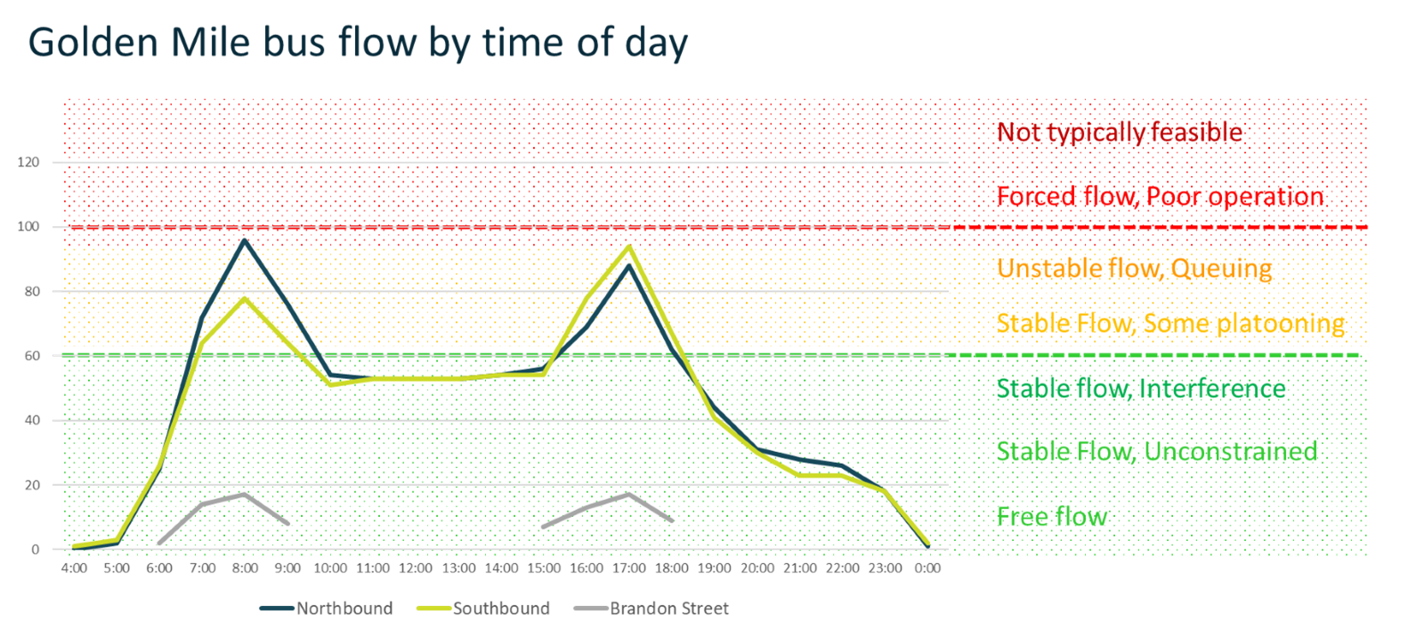
Our current data suggests Golden Mile is exceeding optimum bus flows for this type of facility resulting in congestion and delay. Ideally peak bus numbers would be 60 to 80 buses per hour with 100 considered the maximum that should be operating. With growing bus numbers to meet demand we are already approaching that number in the peaks resulting in the “Unstable Flow and Queuing” that is experienced by Metlink customers in the peaks.
Congestion on busy footpaths is an issue with waiting passengers clogging up city footpaths that lack space for separated waiting areas out of the main flow of pedestrians.

Bus capacity modelling – Second Spine
Advice is current bus capacity for the Golden Mile would ideally be limited to 80 buses per hour to avoid bus delays and congestion. Adding a second waterfront bus corridor effectivity enables us to double capacity for buses through the central city to 160 buses per hour while keeping the maximum number of buses at 80 buses per hour for the two corridors.

More Information
Bus Priority Action Plan
wellington-bus-priority-action-plan-draft.pdf(external link)
Golden Mile Bus Stop Capacity Assessment Memorandum.pdf [PDF, 2.5 MB]
Previous releases/correspondence on GM and Second Spine:
- Greater Wellington — Greater Wellington backs Wellington City Council on bus priority (gw.govt.nz)(external link) – May 2024
- Greater Wellington — Wellington councils considering bus corridor collaboration (gw.govt.nz)(external link) – March 2024
- Greater Wellington — Golden Mile transformation will bring more life into the city says Greater Wellington (gw.govt.nz)(external link) – June 2023
- Greater Wellington — Response to Mayor Whanau - Golden Mile Development (gw.govt.nz)(external link) – March 2024
- Greater Wellington — Rapid Transit Bus Corridor (gw.govt.nz)(external link) – May 2024
Read Greater Wellington’s public transport submission on Wellington City Council’s Long Term Plan
GWRC-submission-on-WCC-LTP-Public-Transport.pdf(external link)
For more information on the road controlling authority, Wellington City Council's indicative work for the Golden Mile roading changes, please visit Golden Mile revitalisation | Let's Talk | Wellington City Council(external link)